
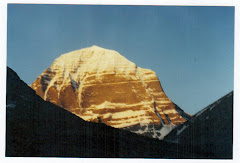
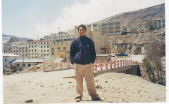
The Everest or khumbu region is justifiably the most famous of all trekking and mountain regions populated by Sherpas, the attractions of this area are the majestic mointain the high mointain villages, the isolated monasteries, and the local poeples. This area includes the highest moutain in the world, Everest at 8,848m, and many of the world’s 8,000m peaks such as Lhotse, cho Oyu, and Makalu. First climbed in 1953, Everest still holds a fascination for many, however the Everest region boasts many more spectacular and beautiful mountains, as well as some of the most rewarding trekking anywhere in the world.
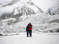
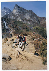
The Everest Base Camp trek is a classic trek which follows in the footsteps of Hillary & Tenzing and ends with an ascent of kala patthar is also known as black rock. Before reaching the Everest Base camp, the trail follows the khumbu Glacier with huge ice pinnacles soaring to unbelievable height.
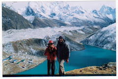
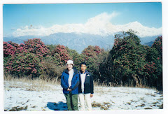
This trek starts with an exhilarating 35 minutes mointain flight into the airstrip at Lukla. From here you trek slowly upwards to the Sherpas capital of Namche Bazaar, following the valley of the Dudh kosi river. It is not long before you glimpse your first view of Everest as it peeks above the Lhotse, Nuptse ridge. At this point it is still many days walk away, but with careful acclimatization it is not long before you find yourself high up in the heart of the khumbu region. You visit Tengboche monastery en route before continuing on to your goal, an ascent of kala patthar, a rocky outcrop to the west of Everest. This vantage point gives fantastic view of the ice Fall and South col as well as the immense south-west face of Everest which was first climbed in 1975 by Chris Bonington's team. This is truly a classic trek, which undoubtedly gives one of the best mountain views in the world. Accommodation and food is provided in the local lodges.
Facts of the Trek
Duration: 13 Days
Trek type: Tea House
Max Altitude: 5545 m.
Minimum Pax: 1 +
Mode of travel: Flight
Grade: Moderate
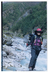
Day 01 : Fly from Kathmandu to Lukla (2886m.) which takes about 30 minutes and trek from Lukla to Phakding (2640 m.) and it takes approximately three hours. You transfer to the domestic airport for your flight to Lukla. It is a small town with an airport. There are few tea shops, lodges, hotels and general stores. You begin today’s trek from Lukla following a gentle climb up the mountainside on the left bank of the Dudh Koshi. Nupla (5885m) can be seen in the distance on the opposite bank, is a peak atop the Kongde Ridge. You descend a mountainside path that merges into your route to Everest, with views to a valley to your right; and at its far end, Kusum Kang (6367m.) The Dudh Kosi approaches as you pass a Mani wall and arrive at Ghat teahouse. You continue along a small path with many climbs and descents following the left bank of Dudh Koshi to Phakding.
Day 02 : Trek from Phakding to Namche Bazaar (3440 m.) and it takes approximately five hours. The trail starts through a level path along the right bank. Thamserku looms skyward on the opposite bank. You cross a stream and climb the terraced hill from the Dudh Koshi route, to arrive at Bengar. The trail now climbs from the riverbed on the left bank into the mountain, through a forest to Chumoa. You continue along a path with many ups and downs; cross a stream, and pass by the tiny village of Monjo. Now you descend the path of stone steps and return to the right bank over a wooden bridge. After a short climb you come to Jorsale’s teahouse and hotel, also stop at the National Park Service where a park entrance fee is collected. After your departure from Jorsale you enter a forested mountainside. You follow a short walk along the riverbed of this V-shaped valley where the river forks - the right is the Dudh Koshi and the left is the Bhote Koshi that leads to Nampa La. After short distance along the Bhote Kosi you begin the steep ascent to Namche Bazar. As the mountain path zigzags uphill, you will emerge at a ridge top rest area that offers excellent views of Everest (8848m) and Lhotse (8516m.) The climb eases somewhat, and Namche Bazar appears ahead as you travel along the path surrounded by pines. Pass the plateau where the Saturday bazaar is held and enter the village. Namche Bazar (3440m) is surrounded on three sides by mountain ranges and opens out only where it faces the Bhote Koshi. The village is a central hub of the area and food, sundries and even mountain climbing equipment may be purchased here.
Day 03 : Rest day at Namche Bazaar (3440 m.) for acclimatization. Namche is tucked away between two ridges amidst the giant peaks of the Khumbu and has an abundance of lodges, tea shops and souvenir shops as well as a magnificent outlook. It is an ideal place to spend a rest day for acclimatization to the high altitude before heading off towards Tyangboche. For the acclimatization you walk upto Khhumjung where you can visit monastery. Khhumjung is densely populated by Sherpa community. You can also enjoy the splendid views of Everest, Ama Dablam, Thamserku, Nuptse, Lhotse, Tawche, Kwangde and so on. Or you can have an hour walk up to the Syangboche (3800m.) where Everest View Hotel is situated above Namche for the outstanding view of Everest, Nuptse, Lhotse, Ama Dablam, Thamserku and Kusum Kangaru. .There is also good views from the National Park Centre and Museum just above the town. This museum exhibits Sherpa culture.
Day 04 : Trek from Namche Bazaar to Tyangboche (3867 m.) which takes about five hours. You leave the village for a climb to the top of a ridge and level mountain path that offers an excellent panorama of Thamserku, Kantega, and Kusum Kangru. To the right there is a steep cliff that drops down to the Dudh Kosi, faintly visible on the valley floor below. As you make your way around a branch ridge, Ama Dablam (6812m) Everest, Lhotse, Nuptse (7955m) and Tawoche (6501m) suddenly appear. After a gentle descent the mountain path ends; you will come to the fork leading to Gokyo. Now you descend past two tea houses and through the village of Trashinga. Though you cannot see it, you can hear the Dudh Kosi and soon you descend to the river and arrive at Phunki Tenga. It is a long climb to Tyangboche; the first half is especially steep. As you climb through the forested zone, the incline eases and a splendid view appears. Continue climbing the mountainside diagonally until you come to the stone gate built by lamas which marks your entry into Tyangboche (3867m). You may use the large plateau in front of the splendid monastery as your campsite. There are a lodge and hotel managed by the National Park Service. Tyangboche is an important lookout point on this course, and the sunset on Everest and Ama Dablam is especially beautiful.
Day 05 :Trek from Tyangboche to Dingboche (4360 m.) which takes approximately five hours. Leave Tyangboche and the Khumbu mountains as a backdrop-and descend a rhododendron covered area to emerge to a pleasant level area. Pass a long Mani stone wall to enter the village of Deboche. Go on to Minlinggo and leave the mountain path to cross over a suspension bridge to the left bank of the Imja Khola. Climb the mountain path while looking up at Ama Dablam and Kantega (6779m) as they appear on the opposite bank. Ascend the chorten-lined route, come to a fork, the upper path passes Pangboche and a monastery, take the lower path to Pangboche Olin and its stone wall-enclosed potato field. Pass through the village and cross a stream to a path skirting a rocky area to terraced hills along the riverbank. The trails climb slowly, winding above the Imjatse River, to a big Mani Stupa. From here, the walk is fairly moderate as you enter the Imjatse Valley beneath the mighty peaks of Ama Dablam, Nuptse and Lhotse with views of the eastern snow capped mountains including the Island Peak or Imjatse (6,189m) Dingboche is a beautiful patchwork of fields enclosed by stone walls protecting the crops of barley, buckwheat and potatoes from the cold winds and grazing animals.
Day 06 :Rest day at Dingboche (4360 m.) for acclimatization. This is a remarkable acclimatization day. There are some breathtaking views of the North face of Ama Dablam and the Lhotse-Nuptse ridge as you explore this beautiful valley that leads up to Island Peak. The walk is short with a good chance to relax in the afternoon. You have another option as you can hike upto Chhukum. From here you can enjoy the panoramic view of Island peak, Ama Dablaml, Makalu, Tawoche peak and others. On the same day you come back to Dingboche and have rest.
Day 07 : Trek from Dingboche to Lobuche (4930 m.) which takes about five and half hours. The onward journey leads north for up to 50-minutes until you come to a mani-prayer Stupa. The trail is gentle looking down to Pheriche village below. Today's walk offers views of the Mt.Tawache, Ama Dablam and to the north-Pokalde (5741m) Kongma-tse (5820m) and the great wall of Nuptse. After two hours walk, the trail from Pheriche joins near Dugla (4595m) before a small wooden bridge over the river of Khumbu glacier. Stop at Dugla, for lunch, before continuing for an hour up a steep hill to the top, where there are views of Mt. Pumori and other peaks west of Everest. After a short break, continue trekking up to Lobuche, hidden and sheltered from the wind.
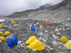
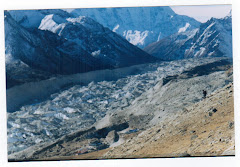
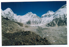
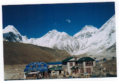
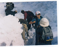
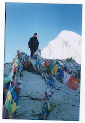
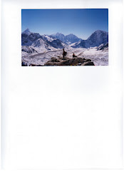
Day 08 :Trek from Lobuche to Everest Base Camp via Gorakshep (5180m.) and it takes about seven hours. Trek up the valley following the rocky moraine path, view icy glacial pond and icebergs down below of Khumbu glacier. After the last rocky moraine dunes, a short downhill walk brings you to Gorakshep, the flat field below Kala Patthar (5545m) and Mt. Pumori (7145m.) Gorakshep is the location of the original Everest Base Camp with the new camp being further up the valley. Now the trail winds through rocky path and Khumbu glacier. The view of Nuptse, Lho-La and Khumbutse appear at the front of you. Sometime the avalanche can be seen on the way. After a great moment, you retrace back passing through Khumbu glacier with magnificent views of Lobuche, Cholatse, Mt. Pumori and Tabuche.
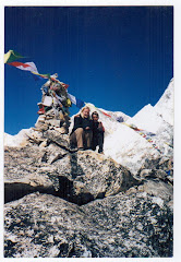
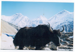
Day 09 :Trek from Gorakshep to Kala Patthar (5545m.) and trek to Pheriche (4243m.) and it takes about six hours. Early morning climb to Kala Patthar (5545m.) and enjoy the view of sunrise. From Kala Patthar you can have a panoramic view of Mt. Everest and many other mountain peaks like Mt. Pumori, Mt. Lingtren, Mt. Khumbetse, Mt. Nuptse, Mt. Lhotse, Mt. Ama Dablam, Mt. Thamserku and many more. Pheriche is the place where one can make phone calls to any part of the world. You can see the mountain Yaks in Pheriche. Yaks are normally regarded as the porters in this area. The town of Pheriche is known as windy town. There you can see the perpendicular walls of Cholatse and Tawache. There is located Himalayan Rescue Association Aid Post and foreign volunteer doctors are to provide medical treatment to trekkers as well as local people.
Day 10 :Trek from Pheriche to Tyangboche (3867 m.)
Day 11 :Trek from Tyangboche to Namche Bazaar (3440 m )
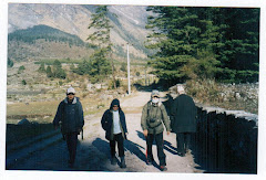
Day 12 : Trek from Namche Bazaar to Lukla (2886 m.)
Day 13 :Fly from Lukla to Kathmandu. You take an early morning flight back to Kathmandu.
Services Included
National Park entry permit, Trekking permit, Land transportation to and fro, Accommodation in lodges during the trek, Food: three meals a day, A guide & required number of porter(s), Essential equipment.
Services Excluded
Personal expenses, Insurance, Tips, Emergency evacuation by Helicopter, Alternative transportation in case of heavy rain, landslide, strike, road blockade etc.


No comments:
Post a Comment