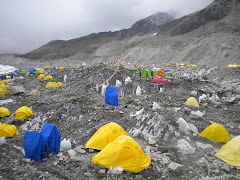
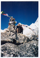
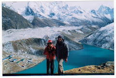
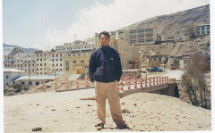
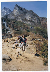
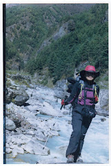
Hello Everyone! I just complete another Everest than just got back other day. It was terrible and really sad to hear one of my guide fellow was killed on plane crash. I wish gone sole will be rest in peace.
Monday, October 1, 2012
Tuesday, September 27, 2011
Langtang and Gosaikunda Treks

The Langtang region is situated to the North of Kathmandu. First Nature Park of Nepal, the natural habitat has remained intact and one can therefore still encounter the red panda and the white collared bear. As we go we encounter the Tamangs and the Sherpas, mountain people who have a way of life close to that of their Tibetan cousins. The sacred lakes of Gosainkundu are on our way to the Laurebina Pass through which the Helambu region can be reached. The lakes, important pilgrimage destinations of the Hinduists reveal sumptuous panoramas of various massifs; the region of the Annapurnas, the Manaslu, the Ganesh Himal, Tibet and the Lirung. The Helambu is a large inhabited valley from where depart multiple itineraries joining Kathmandu. The Sherpa villages of this region are strung along the tracks, revealing their authenticity and charm.
Itinerary
Day 01: Drive to trailhead Syabrubensi (1460m) & over night
Day 02: Syabrubesi (1460m) - Lama Hotel (2470m)
Day 03: Lama Hotel (2478m) - Langtang Village (3430m)
Day 04: Lngtang village (3430m) - Kyanjing Gompa (3850)
Day 05: Exploration day around Kyanjing Gompa
Day 06: Exploration day around Kyanjing Gompa
Day 07: Kyanjing Gompa (3850)- Lama Hotel (2470m)
Day 08: Lama Hotel - Thulo Syabru village (2130m)
Day 09: Thulo Syabru - Sing gompa (3320m)
Day 10: Sing gompa - Gosainkunda (4380m)
Day 11: Gosaikunda - Dunche
Day 12: Dunche - Kathmandu by bus
Trek Cost:
Minimum Group Size: 2 Pax US$
Trek Services Include:
14-Day Langtang Gosaikund lodge trek with trek guide, porters, accommodation in local lodges, meals (breakfast/lunch/dinner), trek permit & Park fees, contribution to guide transport, guide/porter insurance.
Cost Will Not Include:
Personal equipment; hotels/meals in Kathmandu tips; client insurance of any kind; cost of evacuation (if any); bottled/alcoholic drinks; snacks/desserts, beverages (tea/coffee) - other than at breakfast - while on trek; Nepal visa costs; international airport taxes and other expenses of personal nature.
Saturday, February 27, 2010
Annapurna Base Camp trek : 12 day

Annapurna Base Camp trekking is one of the most popular in Annapurna reason. Annapurna Base Camp is surrounded by a cirque of awe-inspiring peaks, including the awesome south face of Annapurna I (8,091m), in a natural amphitheater which is quite simply mind-blowing.
This Trek starts from Pokhara with a short drive to Nayapul. Terraced farmland and traditional villages with Poon and Gurung ethnics make this trekking more attractive. Trail ascends through ancient oak and rhododendron forest, across sparkling streams and past waterfalls. Climbing up the Modi Khola valley towards the Sanctuary you are teased with views of towering peaks of Machhepuchhre (6,993m), Annapurna I (8,091m) and Hiunchuli(6,993m). As the gorge widens, we ascend to Machapuchare Base Camp (3,700m) on the lateral moraine of Annapurana South glacier.
Itinerary Details
Price Include / Exclude
Facts
Highlights
Equipments
FAQS
Day 01: Kathmandu to Pokhara
Day02:Drie to nayapul then trek to Ulleri
Day 03: Ulleri to Ghorepani 2840m.Next early morning hike up to Poonhill to have a massif Annapurna and Dhaulagiri including fishtail.Explore some time over the top and come down to hotel.
Day 04: Ghorepani to Tadapani 2700m.
Day 05: Tadapani to chhomrong
Day 06:Chhomrong to Dovan(2640m)
Day 07: Dovan to Annapurna Base Camp (4130m)
Day 08: Annapurna Base Camp to Bamboo
Day 09: Banboo to Jinu danda
Day 10: Jinu danda to Pothana
Day 11: Pothana to Pokhara
Day 12:Pokhara to Ktm
Day 13: Transfer to airport for final departure.
Friday, February 26, 2010
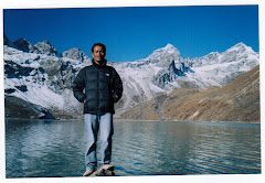
Gokyo Ri Trek : 12 days

The trek to Gokyo provides an excellent opportunity to see an eyeful view of the Mt. Everest at close range.
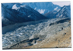
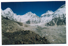
This trek is to be considered as an alternative trek to the traditional Everest Base Camp trek that offers magnificent view of the mountain peaks and the Ngozumpa Glacier- the largest in the Nepal Himalayas.
The image of of this region is associated with the soaring view of the most popular mountains in Nepal, at an altitude of 8000m including Cho Oyu, Everest, Lhotse and Makalu which are clearly visible from Gokyo Ri (5483m.) above Gokyo Lake.
One of the most remarkable feature of the trek is the view of tremendous ice ridge between Cho Oyu and Gyachung (2922m) located in Khumbu region.
This extraordinary trek is also worthy in a sense that it offers an ample opportunity to explore the amazing destination and its impressive sight, which is beyond human imagination.
Itinerary
Day 01: Fly to Lukla (2804 meters) trek to Phakding (2610 meters) 3 hours.
Day 02: Trek to Namche Bazaar (3441 meters) 5.30 hours.
Day 03: Namche Bazaar Acclimatization day. We will spend a day here in order to acclimatize and adjust to the thinning of the air.
Day 04: Trek to Mongla danda (3800 meters) 5 hours.
Day 05: Trek to Dole (4,ooometers) 5 hours.
Day 06:Trek to Machherma (4470 meters) 5 hours.
Day 07: Trek to Gokyo (4790 meters) 5.30 hours.
Day 08: Trek to Gokyo Ri (5483 meters) and then Back to Gokyo 5 hours.
Day 09: Trek to Dole (4200 meters) 6 hours.
Day 10: Trek to Namche Bazaar via Khumjung village (3780 meters). 5 hours.
Day 11: Trek to Lukla (2804 meters) 6 hours.
Day 12: Morning flight to Kathmandu from Lukla.
Trek Cost:
Minimum Group Size: 2 Pax US$
Trek Services Include:
12-Day Gokyo lodge trek with trek guide, porters, accommodation in local lodges, meals (breakfast/lunch/dinner), trek permit & Park fees, contribution to guide transport, guide/porter
insurance and domestic airfare.
Cost Will Not Include:
Personal equipment; hotels/meals in Kathmandu tips; client insurance of any kind; cost of evacuation (if any); bottled/alcoholic drinks; snacks/desserts, beverages (tea/coffee) - other than at breakfast - while on trek; Nepal visa costs; international airport taxes and other expenses of personal netuer
Everest Base Camp Trek : 13 days

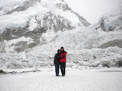
The Everest or khumbu region is justifiably the most famous of all trekking and mountain regions populated by Sherpas, the attractions of this area are the majestic mointain the high mointain villages, the isolated monasteries, and the local poeples. This area includes the highest moutain in the world, Everest at 8,848m, and many of the world’s 8,000m peaks such as Lhotse, cho Oyu, and Makalu. First climbed in 1953, Everest still holds a fascination for many, however the Everest region boasts many more spectacular and beautiful mountains, as well as some of the most rewarding trekking anywhere in the world.
The Everest Base Camp trek is a classic trek which follows in the footsteps of Hillary & Tenzing and ends with an ascent of kala patthar is also known as black rock. Before reaching the Everest Base camp, the trail follows the khumbu Glacier with huge ice pinnacles soaring to unbelievable height.
This trek starts with an exhilarating 35 minutes mointain flight into the airstrip at Lukla. From here you trek slowly upwards to the Sherpas capital of Namche Bazaar, following the valley of the Dudh kosi river. It is not long before you glimpse your first view of Everest as it peeks above the Lhotse, Nuptse ridge. At this point it is still many days walk away, but with careful acclimatization it is not long before you find yourself high up in the heart of the khumbu region. You visit Tengboche monastery en route before continuing on to your goal, an ascent of kala patthar, a rocky outcrop to the west of Everest. This vantage point gives fantastic view of the ice Fall and South col as well as the immense south-west face of Everest which was first climbed in 1975 by Chris Bonington's team. This is truly a classic trek, which undoubtedly gives one of the best mountain views in the world. Accommodation and food is provided in the local lodges.
Facts of the Trek
Duration: 13 Days
Trek type: Tea House
Max Altitude: 5545 m.
Minimum Pax: 1 +
Mode of travel: Flight
Grade: Moderate
Day 01 : Fly from Kathmandu to Lukla (2886m.) which takes about 30 minutes and trek from Lukla to Phakding (2640 m.) and it takes approximately three hours. You transfer to the domestic airport for your flight to Lukla. It is a small town with an airport. There are few tea shops, lodges, hotels and general stores. You begin today’s trek from Lukla following a gentle climb up the mountainside on the left bank of the Dudh Koshi. Nupla (5885m) can be seen in the distance on the opposite bank, is a peak atop the Kongde Ridge. You descend a mountainside path that merges into your route to Everest, with views to a valley to your right; and at its far end, Kusum Kang (6367m.) The Dudh Kosi approaches as you pass a Mani wall and arrive at Ghat teahouse. You continue along a small path with many climbs and descents following the left bank of Dudh Koshi to Phakding.
Day 02 : Trek from Phakding to Namche Bazaar (3440 m.) and it takes approximately five hours. The trail starts through a level path along the right bank. Thamserku looms skyward on the opposite bank. You cross a stream and climb the terraced hill from the Dudh Koshi route, to arrive at Bengar. The trail now climbs from the riverbed on the left bank into the mountain, through a forest to Chumoa. You continue along a path with many ups and downs; cross a stream, and pass by the tiny village of Monjo. Now you descend the path of stone steps and return to the right bank over a wooden bridge. After a short climb you come to Jorsale’s teahouse and hotel, also stop at the National Park Service where a park entrance fee is collected. After your departure from Jorsale you enter a forested mountainside. You follow a short walk along the riverbed of this V-shaped valley where the river forks - the right is the Dudh Koshi and the left is the Bhote Koshi that leads to Nampa La. After short distance along the Bhote Kosi you begin the steep ascent to Namche Bazar. As the mountain path zigzags uphill, you will emerge at a ridge top rest area that offers excellent views of Everest (8848m) and Lhotse (8516m.) The climb eases somewhat, and Namche Bazar appears ahead as you travel along the path surrounded by pines. Pass the plateau where the Saturday bazaar is held and enter the village. Namche Bazar (3440m) is surrounded on three sides by mountain ranges and opens out only where it faces the Bhote Koshi. The village is a central hub of the area and food, sundries and even mountain climbing equipment may be purchased here.
Day 03 : Rest day at Namche Bazaar (3440 m.) for acclimatization. Namche is tucked away between two ridges amidst the giant peaks of the Khumbu and has an abundance of lodges, tea shops and souvenir shops as well as a magnificent outlook. It is an ideal place to spend a rest day for acclimatization to the high altitude before heading off towards Tyangboche. For the acclimatization you walk upto Khhumjung where you can visit monastery. Khhumjung is densely populated by Sherpa community. You can also enjoy the splendid views of Everest, Ama Dablam, Thamserku, Nuptse, Lhotse, Tawche, Kwangde and so on. Or you can have an hour walk up to the Syangboche (3800m.) where Everest View Hotel is situated above Namche for the outstanding view of Everest, Nuptse, Lhotse, Ama Dablam, Thamserku and Kusum Kangaru. .There is also good views from the National Park Centre and Museum just above the town. This museum exhibits Sherpa culture.
Day 04 : Trek from Namche Bazaar to Tyangboche (3867 m.) which takes about five hours. You leave the village for a climb to the top of a ridge and level mountain path that offers an excellent panorama of Thamserku, Kantega, and Kusum Kangru. To the right there is a steep cliff that drops down to the Dudh Kosi, faintly visible on the valley floor below. As you make your way around a branch ridge, Ama Dablam (6812m) Everest, Lhotse, Nuptse (7955m) and Tawoche (6501m) suddenly appear. After a gentle descent the mountain path ends; you will come to the fork leading to Gokyo. Now you descend past two tea houses and through the village of Trashinga. Though you cannot see it, you can hear the Dudh Kosi and soon you descend to the river and arrive at Phunki Tenga. It is a long climb to Tyangboche; the first half is especially steep. As you climb through the forested zone, the incline eases and a splendid view appears. Continue climbing the mountainside diagonally until you come to the stone gate built by lamas which marks your entry into Tyangboche (3867m). You may use the large plateau in front of the splendid monastery as your campsite. There are a lodge and hotel managed by the National Park Service. Tyangboche is an important lookout point on this course, and the sunset on Everest and Ama Dablam is especially beautiful.
Day 05 :Trek from Tyangboche to Dingboche (4360 m.) which takes approximately five hours. Leave Tyangboche and the Khumbu mountains as a backdrop-and descend a rhododendron covered area to emerge to a pleasant level area. Pass a long Mani stone wall to enter the village of Deboche. Go on to Minlinggo and leave the mountain path to cross over a suspension bridge to the left bank of the Imja Khola. Climb the mountain path while looking up at Ama Dablam and Kantega (6779m) as they appear on the opposite bank. Ascend the chorten-lined route, come to a fork, the upper path passes Pangboche and a monastery, take the lower path to Pangboche Olin and its stone wall-enclosed potato field. Pass through the village and cross a stream to a path skirting a rocky area to terraced hills along the riverbank. The trails climb slowly, winding above the Imjatse River, to a big Mani Stupa. From here, the walk is fairly moderate as you enter the Imjatse Valley beneath the mighty peaks of Ama Dablam, Nuptse and Lhotse with views of the eastern snow capped mountains including the Island Peak or Imjatse (6,189m) Dingboche is a beautiful patchwork of fields enclosed by stone walls protecting the crops of barley, buckwheat and potatoes from the cold winds and grazing animals.
Day 06 :Rest day at Dingboche (4360 m.) for acclimatization. This is a remarkable acclimatization day. There are some breathtaking views of the North face of Ama Dablam and the Lhotse-Nuptse ridge as you explore this beautiful valley that leads up to Island Peak. The walk is short with a good chance to relax in the afternoon. You have another option as you can hike upto Chhukum. From here you can enjoy the panoramic view of Island peak, Ama Dablaml, Makalu, Tawoche peak and others. On the same day you come back to Dingboche and have rest.
Day 07 : Trek from Dingboche to Lobuche (4930 m.) which takes about five and half hours. The onward journey leads north for up to 50-minutes until you come to a mani-prayer Stupa. The trail is gentle looking down to Pheriche village below. Today's walk offers views of the Mt.Tawache, Ama Dablam and to the north-Pokalde (5741m) Kongma-tse (5820m) and the great wall of Nuptse. After two hours walk, the trail from Pheriche joins near Dugla (4595m) before a small wooden bridge over the river of Khumbu glacier. Stop at Dugla, for lunch, before continuing for an hour up a steep hill to the top, where there are views of Mt. Pumori and other peaks west of Everest. After a short break, continue trekking up to Lobuche, hidden and sheltered from the wind.
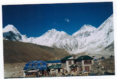
Day 08 :Trek from Lobuche to Everest Base Camp via Gorakshep (5180m.) and it takes about seven hours. Trek up the valley following the rocky moraine path, view icy glacial pond and icebergs down below of Khumbu glacier. After the last rocky moraine dunes, a short downhill walk brings you to Gorakshep, the flat field below Kala Patthar (5545m) and Mt. Pumori (7145m.) Gorakshep is the location of the original Everest Base Camp with the new camp being further up the valley. Now the trail winds through rocky path and Khumbu glacier. The view of Nuptse, Lho-La and Khumbutse appear at the front of you. Sometime the avalanche can be seen on the way. After a great moment, you retrace back passing through Khumbu glacier with magnificent views of Lobuche, Cholatse, Mt. Pumori and Tabuche.
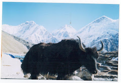
Day 09 :Trek from Gorakshep to Kala Patthar (5545m.) and trek to Pheriche (4243m.) and it takes about six hours. Early morning climb to Kala Patthar (5545m.) and enjoy the view of sunrise. From Kala Patthar you can have a panoramic view of Mt. Everest and many other mountain peaks like Mt. Pumori, Mt. Lingtren, Mt. Khumbetse, Mt. Nuptse, Mt. Lhotse, Mt. Ama Dablam, Mt. Thamserku and many more. Pheriche is the place where one can make phone calls to any part of the world. You can see the mountain Yaks in Pheriche. Yaks are normally regarded as the porters in this area. The town of Pheriche is known as windy town. There you can see the perpendicular walls of Cholatse and Tawache. There is located Himalayan Rescue Association Aid Post and foreign volunteer doctors are to provide medical treatment to trekkers as well as local people.
Day 10 :Trek from Pheriche to Tyangboche (3867 m.)
Day 11 :Trek from Tyangboche to Namche Bazaar (3440 m )
Day 12 : Trek from Namche Bazaar to Lukla (2886 m.)
Day 13 :Fly from Lukla to Kathmandu. You take an early morning flight back to Kathmandu.
Services Included
National Park entry permit, Trekking permit, Land transportation to and fro, Accommodation in lodges during the trek, Food: three meals a day, A guide & required number of porter(s), Essential equipment.
Services Excluded
Personal expenses, Insurance, Tips, Emergency evacuation by Helicopter, Alternative transportation in case of heavy rain, landslide, strike, road blockade etc.
Monday, September 29, 2008
LANGTANG GOSAIKUND TREK

The Langtang valley is aptly called " the valley of glaciers". Here the mountain?scape is spectacular. On either side of valley, mountains rise, soaring into the sky. The valley offers pine forest, slow moving rivers and swift mountain streams, rugged rock and snow?capped peaks, grassy downs and meadows strewn with daisies and wild primulas. In the upper part of valley there are snow bridges spanning angry torrents, high passes enveloped in mist, tiny lakes with icebergs floating on them and water of crystalline brightness. There are also high mountains of solid ice.
ITINERARY
Day 01: Kathmandu to Syabru besi
Day 02: Syabru besi to Lama hotel
Day 03: Lama hotel to Langtang
Day o4: Langtang to Kyenjing gomp
Day 05: Kyenjing gomp
Day 06: Kyenjing gomp to Lama hotel
Day 07: Lama hotel to Tholo syabru
Day 08: Tholosyabru to Sing gomp
Day 09: Sing gomp to Gosaikund
Day 10: Gosaikund to Gopte
Day 11: Gopte to Kutumsang
Day 12: Kutumsang to Chisapani
Day 13: Chisapani to Kathmandu
Friday, September 26, 2008
Round Annapurna Treks

Few places in he worlds have such a splendid variety of natural beauty as the Annapurna region. It is a rare combination of long arrays of snow capped peaks, crystal clear lakes, turbulent rivers with deep gorges, Tibetan monasteries, hot-springs, and picturesque villages inhabited by simple and friendly ethnic people.
ITINERARY
Day 01: Kathmandu To Besisahar
Day 02: Besisahar to Bhahundanda
Day 03: Bhahundanda to Jagat
Day 04: Jagat to Darapani
Day 05: Darapani to Chame
Day 06: Chame to Pisang
Day 07: Pisang to Manang
Day 08: Manang
Day 09: Manang to Lether
Day 10: Lether to Phedi
Day 11: Phedi to Muktinaht
Day 12: Muktinaht to Marpha
Day 13: Marpha to Ghassa
Day 14: Ghassa to tatopani
Day 15: Tatopani to Shikha
Day 16: Shikha to Ghorepani
Day 17: Ghorepani to pokhara
Day 18: Pokhara to Kathmandu
Subscribe to:
Posts (Atom)